

GPS-Tracks for iPhone app for iPhone and iPad
Developer: GEO-Tracks GmbH, Zugerstrasse 1, CH-6330 Cham
First release : 09 Apr 2010
App size: 9.95 Mb
Multimedia-Tour guide with Topo maps for the european alpine region. GPS-Tracks for iPhone is designed for the application at hiking, theme trails, GEO-caching, cycling, snow trail tours, ski tours, MTB, site seeing tours, etc.
Runs on:
All iPhones from version 4, iPads and iPods with WiFi-connection.
Attention:
If the App is moved to the background, the GPS-receiving continues. This can quickly discharge the battery.
Features:
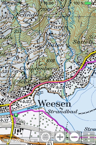
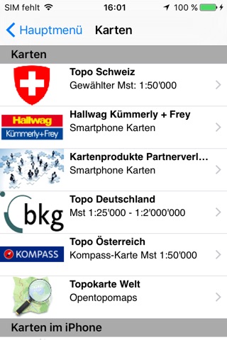
- Original, free Topo maps from scale 1:25000 for Switzerland, Germany and Austria. Openstreetmaps and Opentopomaps for worldwide use.
- Complete footpath, cycling and further networks to overlay the maps. Examples: footpath network Switzerland, cycling network Switzerland and South Germany, ....
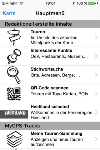
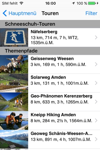
- «Top of»-routes: Integrated Tour-guide with over 7500 professional created routes in the field of hiking, theme trails, cycling, mountainbike, ski tours, snow trail tours, transalp, etc. Following the principle: just the best routes of the region!
- Multimedia routes with Dia-shows and Audio-contents: Exactly located explanations from the expert. Constantly incrasing offer.
- Over 250000 Points of interests, like hotels, museums, sights, ... – provided by our tourism-partners.
- Routing via leisure-path networks e.g. from point A to point B via footpaht network.
- Free text search in all databases. E.g. for mountain names, locations, addresses, etc. Alignment oft he map on these points.
- Recording of your own routes and waypoints and saving them on the iPhone or on www.GPS-Tracks.com.
- Revolutionary: With a free account on www.GPS-Tracks.com you can plan your routes (using the whole assortment of Topo- and satellite maps) and transfer them to the iPhone without any installation of software or maps. You do not need to connect the iPhone to the computer. Plan routes unlimitedly and recall them anytime and anywhere.
- All routes, POIs and maps can be saved on the iPhone (in case there is no telephone connection on the way).
- Friends-function to show your position realtime in the map of the iPhone of your friends.
- Data fields with height, distance, direction, coordinate, trip-dates, etc. to overlay..
- Simple user guidance: without initial effort or previous knowledge easily operated.
Important:
- All data can be saved on the iPhone. You can e.g. transfer data at home on a WiFi network to your iPhone and hence will be independent of a data connection on the way. If additional data is loaded through the internet connection on the way, we recommend to open a data subscription at your telecommunications provider. 30 MB per month are enough for that purpose. For a route Tour incl. all map data approx. 3 MB are loaded.
This App and its content were developed with the support from i.a.:
- Adelboden / Frutigen Tourismus
- Allgäu Tourismus
- Brigels Tourismus
- Colltex Skihaftfelle
- Chur Tourismus
- Davos Klosters Tourismus
- Engadin- St.Moritz Tourismus
- Entlebuch Unesco Biospärenreservat
- Heidiland Tourismus
- Jungfrau-Tourismus
- Vierwaldstättersee / Lakeluzern.ch Tourismus
- Lenzerheide Tourismus
- Liechtenstein Tourismus
- Luzern Tourismus
- Schweizerischer Alpen-Club SAC
- St.Gallen Business Location
- Regiun Surselva
- Ticino Tourismus
- Viamala Tourismus
- Region Willisau
- Zürichsee Tourismus
- Bad Zurzach
- Interlaken Tourismus